Creation place
Creation place
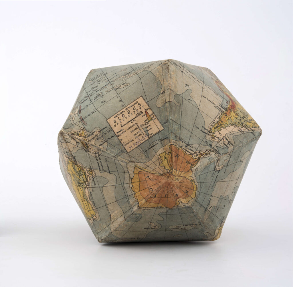
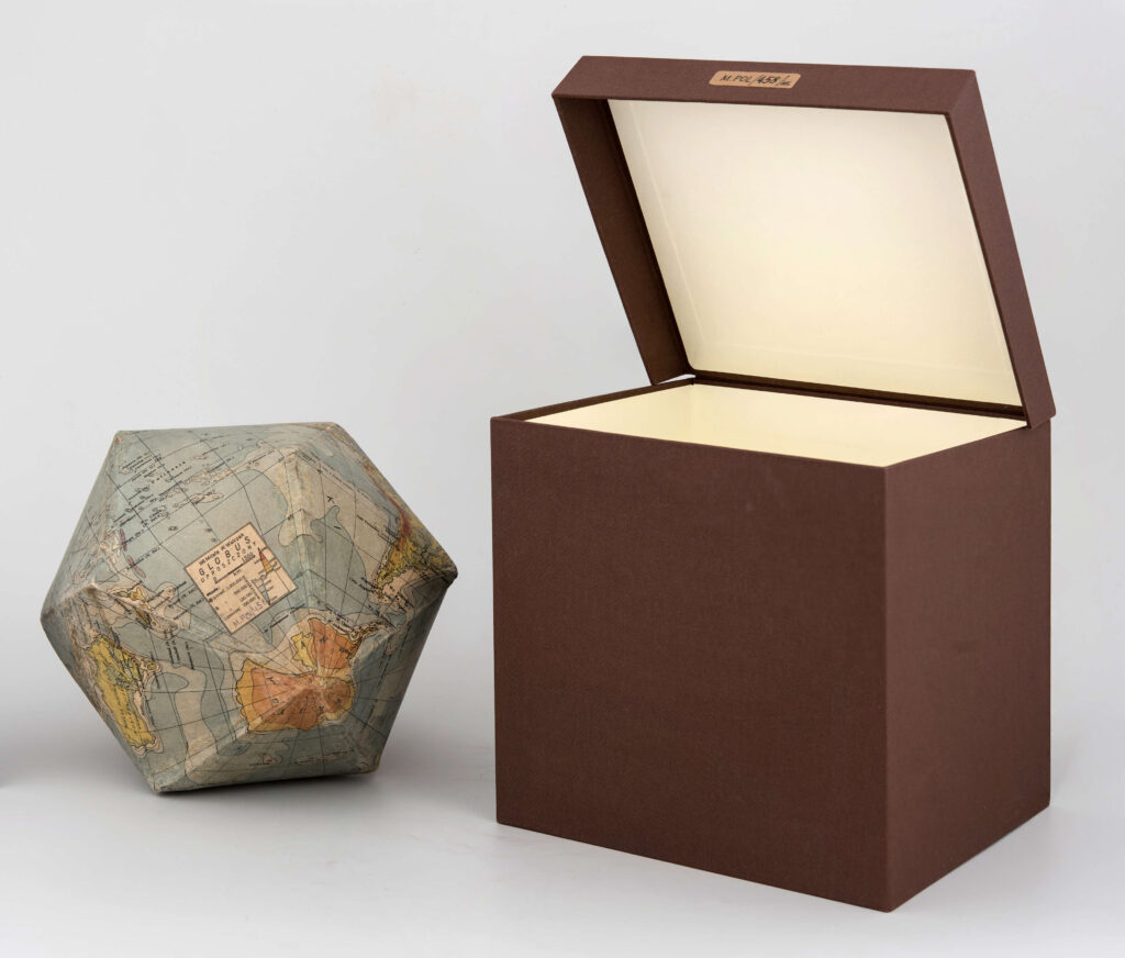
Amsterdam (Netherlands) Antwerp (Belgium) Augsburg (Germany, Bavaria) Austria (Europe) Austria (Europe), Poland (Europe) Austria-Hungary (Europe; historic state) Austria-Hungary (Europe; Historical State) Bałtów (Lublin Province, Puławy County, Żyrzyn Commune) Banachy (Podkarpackie Province, Niski County, Harasiuki Commune) Baranówka (Lublin Province, Lubartów County, Lubartów Commune) Basonia (Lublin Voivodeship, Opole County, Józefów nad Wisłą commune) Basonia (Lublin Voivodeship, Opole County, Józefów nad Wisłą commune) (town) Belgium (Europe) Berlin (Germany) bialski, poviat (lubelskie voivodship) Biała (Lublin Province, Janów County, Janów Lubelski Commune) (First or Second) Bielsko (Lublin Province, Opole County, Karczmiska commune) (town) Biłgoraj (Lubelskie Voivodeship, Biłgoraj Poviat) (?) Biłgoraj (Lublin Province, Biłgoraj County) Biłgoraj (Lublin Voivodeship, Biłgoraj County) Biłgorajski, poviat (lubelskie voivodship) Biłgorajski, poviat (lubelskie voivodship) (road Frampol – Janów) Biłgorajski, poviat (lubelskie voivodship), lubelskie, voivodship (Poland) Bishopric of Liége (Holy Roman Empire; historical state), Józefów (Lublin Province, Biłgoraj poviat, Józefów commune) Biskupice (Lublin Province, Świdnica County, Trawniki Commune) Bliskowice (Lublin Province, Kraśnik County, Annopol Commune) Bochotnica (Lublin Province, Puławy County, Kazimierz Dolny Commune) Breda (Netherlands) Brzeźnica Książęca (Lublin Province, Lubartów County, Niedźwiada commune) Budapest (Hungary) Budziska (Lubelskie Province, Łuków County, Adamów Commune) Bukowa (Lublin Province, Biłgoraj Poviat, Biłgoraj Commune) Bychawka (Lublin Province, Lublin County, Bychawa Commune) Bystra (Silesia Province, Bielsko County, Wilkowice Commune) Castle in Lublin (Lublin) (place of discovery), Lublin (Lublin Voivodeship) Castle in Lublin (Lublin) (place of finding), Lublin (Lublin Province) Castle in Lublin (Lublin) (town), Lublin (Lublin Province) Castle in Lublin (Lublin), Lublin (Lublin Province) Chełm (Lublin Province) Chełsty (Warmian-Masurian Voivodeship, Działdowo County, Lidzbark Commune) China (Asia) Chlewiska (Lublin Province, Lubartów County, Lubartów Commune) Chłopków (Lublin Province, Biłgoraj County, Frampol Commune) Chodel (Lubelskie Province, Opole County, Chodel Commune) (commune) Ciechanki Łęczyńskie (Lublin Province, Łęczyński County, Łęczna Commune) Cielemęc (Mazowieckie Province, Siedlce County, Zbuczyn Commune) Ćmielów (Świętokrzyskie Province, Ostrowiec County, Ćmielów Commune) Cologne (Germany, North Rhine-Westphalia), Germany (Europe) Czech Republic (Europe) Czermno (Lublin Voivodeship, Tomaszów poviat, Tyszowce commune) (place of finding) Czermno (Lublin Voivodeship, Tomaszów poviat, Tyszowce commune) (town) Czernięcin Główny (Lublin Province, Biłgoraj County, Turobin Commune) Czerniejów (Lublin Province, Lubartów County, Serniki Commune) Dąbrowa-Las, part of the city of Lublin (Lublin Province), formerly as Zemborzyce-Dąbrowa (place of finding) Dębowica (Lublin Province, Łuków County, Trzebieszów Commune) Delft (Netherlands) Deszkowice (Lublin Province, Zamość County, Sułów Commune) Dołhobrody (Lublin Province, Włodawa County, Hanna Commune), Lublin Province, Province (Poland) Dora (Ukraine, Ivano-Frankivsk region, Yeremche) Drelów (Lublin Province, Biała Podlaska County, Drelów Commune) Dresden (Germany) Dresden (Germany), Lublin (Lublin Province) Drohobych (Ukraine, Lviv region) Duchy of Warsaw (Poland; historic state) Duchy of Warsaw (Poland; historic state) Dys (Lublin Voivodeship, Lublin Poviat, Niemce Commune) Dzierzkowice, commune (Lublin Voivodeship, Kraśnik County) Dzierzkowice-Podwody Dzwola (Lublin Province, Janowski County, Dzwola Commune) Egypt (Africa) Egypt (Africa) (?) England (Europe, Great Britain) (?) England (Europe, UK) Europe Fajsławice (Lublin Province, Krasnystaw County, Fajsławice Commune) Fiukówka (Lublin Province, Łuków County, Krzywda Commune) Flanders, a historic land (Europe) France (Europe) France (Europe), Poland (Europe) Frankfurt am Main (Germany, Hesse) Fulda (Germany, Hesse) Garbów (Lublin Province, Lublin County, Garbów Commune) Gdansk (Pomeranian Voivodeship) Gdańsk (Pomeranian Voivodeship) General Government Geneva (Switzerland) Germany (Europe) Germany (Europe) (?) Germany (Europe) (Berlin) Germany (Europe) Central (?), Silesia, a historic land (Central Europe) (?) Germany (Europe), Cologne (Germany, North Rhine-Westphalia) Germany (Europe), Third Reich (Europe; historical state) Głogów (Lower Silesia Province, Głogów County) Gołąb (Lublin Province, Puławy County, Puławy Commune) Gołąb (Lublin Province, Puławy County, Puławy Commune) (place of finding) Goraj (Lublin Province, Biłgoraj County, Goraj Commune) Górecko Kościelne (Lublin Voivodeship, Biłgoraj County, Józefów Commune) Górka Lubartowska (Lublin Province, Lubartów County, Niedźwiada commune) Gościeradów, commune (Lublin Voivodeship, Kraśnik County) Greater Poland, a historical land (Poland) Grodno (Belarus, Grodno region) Grodno (Belarus, Grodno region) (?) Hamburg (Germany) Holy Roman Empire, a historical state (Europe) Hołowno (Lublin Province, Parczewski County, Podedwórze Commune) Horodysko (Lublin Voivodeship, Chełm poviat, Leśniowice commune) (place of finding) Horodysko (Lublin Voivodeship, Chełm poviat, Leśniowice commune) (town) Horodyszcze (Lublin Province, Biała Podlaska County, Wisznice Commune), Lublin Province, Province (Poland) Hrebenne (Lublin Province, Tomaszów County, Lubycza Królewska Commune) hrubieszowski, poviat (lubelskie voivodeship) or poviat Tomaszów Lubelski?, Lublin Province (Poland) hrubieszowski, poviat (lubelskie voivodship), lubelskie, voivodship (Poland) Hungary (Europe) Huta Krzeszowska (Subcarpathian Voivodeship, Niski Poviat, Harasiuki Commune) Irkutsk (Russia) Italy (Europe) Italy (Europe) ? Jabłonna (Lublin Province, Lublin County, Jabłonna commune) Janow Lubelski Janów Lubelski (Lublin Voivodeship, Janów County, Janów Lubelski Commune) Janowiec (Lublin Province, Puławy County, Janowiec Commune) Janowski, poviat (lubelskie voivodeship) Jaszczów (Lublin Province, Łęczyński County, Milejów Commune) Jaszczów (Lublin Province, Łęczyński County, Milejów commune) (town) Jeleniec (Lublin Province, Łuków County, Stanin Commune) Jeziernia (Lublin Province, Tomaszów County, Tomaszów Lubelski Commune) Józefów (Lublin Province, Biłgoraj County, Józefów Commune) Kamionka Bużańska (Ukraine, Lviv region) Katowice (Silesian Voivodeship) Kazimierz Dolny (Lublin Province, Puławy County, Kazimierz Dolny Commune) Kazimierz Dolny (Lublin Province, Puławy County, Kazimierz Dolny Commune)? Kazimierz Dolny (Lublin Voivodeship, Puławy County) Kazimierz Dolny, commune (Lublin Province, Puławy County) Kerensk (Russia) Kielce (Swietokrzyskie Voivodeship) Kiev (Ukraine) Kij (Lublin Province, Łuków County, Stanin Commune) KL Auschwitz-Birkenau, German Nazi concentration camp, Oświęcim (Lesser Poland Voivodeship, Oświęcim County) KL Lublin, German Nazi concentration camp, Majdanek, part of the city of Lublin (Lublin Voivodeship) Klementowice (Lubelskie Voivodeship, Puławy poviat, Kurów commune) (town), Puławy (Lubelskie Voivodeship, Puławy poviat) (poviat), Lubelskie, voivodeship (Poland) (voivodeship) Knee (Lublin Province, Parczewski County, Jabłoń Commune) Kobyłka (Masovian Voivodeship, Wołomin poviat, Kobyłka commune) Kobyłka (Mazowieckie Voivodeship, Wolomin County, Kobyłka Commune) Kocudza (Lublin Province, Janowski County, Dzwola Commune) Kodeń (Lubelskie Voivodeship, Biała Podlaska County, Kodeń commune) (surroundings) Kolomyia (Ukraine, Ivano-Frankivsk region) Kolonia Nieszawa (Lublin Province, Opole County, Józefów nad Wisłą commune) (town) Kopina (Lubelskie Voivodeship, Łuków poviat, Stanin commune) (town), Lubelskie, voivodeship (Poland) (voivodeship) Korytków Duży (Lublin Voivodeship, Biłgoraj poviat, Biłgoraj commune) Korzec (Ukraine, Rivne region) (now), Volyn, historical region (Ukraine), Poland (Europe) then Kosiorów (Lublin Province, Opole County, Wilków Commune) (town) Kotorów (Lubelskie Province, Hrubieszowski County, Werbkowice Commune) Kotorów (Lublin Province, Hrubieszowski County, Werbkowice Commune) (town) Krakow (Lesser Poland Province), Lublin (Lublin Province) Kraków (Lesser Poland Voivodeship) Kraków (Lesser Poland Voivodeship) Krakow (Lesser Poland Voivodeship) Krakow (Lesser Poland Voivodeship) (?) Krakow (Lesser Poland Voivodeship), Lublin (Lublin Voivodeship) Kraśnik (Lublin Voivodeship, Kraśnik County) Kraśnik, commune (Lublin Voivodeship, Kraśnik County) Kraśnik, commune (Lublin Voivodeship, Kraśnik County) Kozarów Kraśnik, poviat (lubelskie voivodship) Krasnystaw, poviat (lubelskie voivodeship) Krężnica Jara (Lublin Province, Lublin County, Niedrzwica Duży commune) Krężnica Jara (Lublin Province, Lublin Poviat, Niedrzwica Duży commune) (place of finding) Krynica-Zdrój (Lesser Poland Voivodeship, Nowy Sącz County, Krynica-Zdrój Commune) Krzczonów (Lublin Province, Lublin County, Krzczonów Commune) Krzemień (Lublin Province, Janowski County, Dzwola Commune) Krzywowólka (Lublin Province, Biała Podlaska County, Sławatycze Commune) Ksawerynów (Lublin Province, Łuków County, Wola Mysłowska Commune) Kurów (Lubelskie Province, Puławy County, Kurów Commune), Lublin Province, Province (Poland) Kurów (Lublin Province, Puławy County, Kurów Commune) Kwasówka (Lublin Province, Biała Podlaska County, Drelów Commune) Las Stocki (Lubelskie Voivodeship, Puławy poviat, Końskowola commune) Las Stocki (Lubelskie Voivodeship, Puławy poviat, Końskowola commune) (town) Le Mont-Saint-Michel (France) Leiden (Netherlands) Leiden (the Netherlands), the Netherlands, a historic land (Europe) Leipzig (Germany, Saxony) Leipzig (Germany, Saxony) place of publication Leszkowice (Lubelskie Province, Lubartów County, Ostrówek Commune) Lipiny Dolne (Lublin Province, Biłgoraj County, Potok Górny Commune) Lipków (Masovian Voivodeship, Warsaw West Poviat, Stare Babice Commune) Lithuania (Europe) London (UK, England) London (United Kingdom, England) Lubartów (Lublin Province, Lubartów County) lubartowski, poviat (lubelskie voivodeship) Lubiąż (Lower Silesia Province, Wołów County, Wołów Commune) Lubiczyn (Lublin Province, Parczewski County, Dębowa Kłoda Commune) Lublin (Lubelskie Province), Biskupice (Łódź Province, Sieradz County, Sieradz Commune), Warsaw (Mazowieckie Province) Lublin (Lubelskie Voivodeship) (?) Lublin (Lubelskie Voivodeship), Lubelskie, Voivodeship (Poland) Lublin (Lubelskie Voivodeship), Lubelskie, Voivodeship (Poland), Thursday, part of the city of Lublin (Lublin Voivodeship) (city) Lublin (Lubelskie Voivodeship), Warsaw (Masovian Voivodeship) Lublin (Lublin Province Lublin (Lublin Province) Lublin (Lublin Province) ul. Gliniana 13 (town), Lublin (Lubelskie Voivodeship) (poviat), Lublin, voivodeship (Poland) (voivodeship) Lublin (Lublin Province), Biskupice (Łódź Province, Sieradz County, Sieradz Commune) Lublin (Lublin Province), Castle Square (Lublin) Lublin (Lublin Province), Lviv (Ukraine, Lviv Region) Lublin (Lublin Province), Poland (Europe) Lublin (Lublin Voivodeship) Lublin (Lublin Voivodeship) Castle Hill Lublin (Lublin Voivodeship), Dresden (Germany) Lublin (Lublin Voivodeship), Leipzig (Germany, Saxony) Lublin (Lublin Voivodeship), Stockholm (Sweden) Lublin (Lublin Voivodeship), Warsaw (Masovia Voivodeship) Lublin, poviat (lubelskie voivodship) Lublin, poviat (lubelskie voivodship), lubelskie, voivodship (Poland) Lublin, poviat (Lublin Voivodeship) Lublin, voivodeship (Poland) Lviv (Ukraine, Lviv Oblast) Lviv (Ukraine, Lviv region) Lviv (Ukraine, Lviv region) (Poland) Lviv (Ukraine, Lviv region), Warsaw (Masovian Voivodeship) Lyon (France) Łazory (Podkarpackie Province, Niski County, Harasiuki Commune), Lublin Province, Province (Poland) Łazory (Podkarpackie Voivodeship, Niski Poviat, Harasiuki Commune) Łęczna (Lubelskie Province, Łęczna County, Łęczna Commune) Łózki (Lublin Province, Biała Podlaska County, Drelów Commune) Łuków (Lublin Province, Łuków County) Łuków, poviat (lubelskie voivodeship) Łukowa (Lubelskie Province, Biłgoraj County, Łukowa Commune) Łuszków (Lubelskie Province, Hrubieszowski County, Horodło Commune), Lublin Province, Province (Poland) Magdeburg (Germany, Saxony-Anhalt) Majdan Pławanicki (Lublin Province, Chełm County, Kamień Commune) Majdan Stary (Lublin Voivodeship, Biłgoraj County, Księżpol Commune) Makarówka (Masovian Voivodeship, Łosicki County, Huszlew Commune) Malinówka (Lubelskie Voivodeship, Chełm poviat, Sawin commune) Masów, part of the city of Dęblin (Lublin Province, Rycki County, Dęblin Commune) (place of finding) Masów, part of the city of Dęblin (Lublin Province, Rycki County, Dęblin Commune) (town) Masów, part of the city of Dęblin (Lublin Province, Rycki County, Dęblin Commune), poviat rycki, voiv. Lublin (place of finding) Matiaszówka (Lublin Province, Biała Podlaska County, Biała Podlaska County, Commune (Lublin Province, Biała Podlaska County) Meissen (Germany, Saxony) Międzyleś (Lubelskie Province, Biała Podlaska County, Tuczna County), Biała Podlaska Province (Lubelskie Province, Biała Podlaska County) Międzyleś (Lublin Province, Biała Podlaska County, Tuczna Commune) Międzylesie (Lublin Province, Biała Podlaska County, Konstantynów Commune) Międzyrzec Podlaski (Lublin Province, Biała Podlaska County) Milanówek (Mazowieckie Voivodeship, Grodzisk County, Milanówek Commune) Milejów (Lublin Province, Łęczyński County, Milejów commune) (town) Moscow (Russia) Naliboki (Belarus, Minsk region), Urzecze (Belarus, Minsk region) Nałęczów (Lublin Province, Puławy County, Nałęczów Commune) Nałęczów (Lublin Voivodeship, Puławy County, Nałęczów Commune) Nancy (France) Neighbor (Lubelskie Voivodeship, Zamość poviat, Sułów commune) (town) Netherlands (Europe) Netherlands (Europe)? New York (United States) Nieborów (Łódzkie Voivodeship, Łowicz poviat, Nieborów commune) Niedrzwica Duży (Lubelskie Voivodeship, Lublin Poviat, Niedrzwica Duży commune) Norrköping (Sweden) Nuremberg (Germany, Bavaria) Nuremberg (Germany, Bavaria), Dresden (Germany) Okopy (Lublin Voivodeship, Chełm poviat, Dorohusk commune) Olszanka (Lublin Province, Lublin County, Krzczonów Commune) Opoka (Lubelskie Province, Puławy County, Końskowola Commune) Opole (Lublin Province, Parczewski County, Podedwórze Commune) Opole Lubelskie (Lubelskie Province, Opole County, Opole Lubelskie Commune) Orońsko (Masovian Voivodeship, Szydłowiec poviat, Orońsko commune) (town) Ostrów Lubelski (Lubelskie Province, Lubartów County, Ostrów Lubelski Commune) Pachole (Lublin Province, Parczewski County, Dębowa Kłoda Commune) Paris (France) Paris (France), Puławy (Lubelskie Province, Puławy County) (picture) Paris (France), Puławy (Lublin Province, Puławy County) Paris (France), Puławy, commune (Lubelskie Voivodeship, Puławy poviat) (figure) Paris France) Petersburg (Russia) Piaski (Lublin Province, Świdnica County, Piaski Commune) Piotrków (Lublin Voivodeship, Lublin Poviat, Jabłonna commune) Podlodów (Lublin Province, Tomaszów County, Łaszczów Commune) Podlodów (Lublin Province, Tomaszów County, Łaszczów Commune) (town) Podlodów (Lublin Province, Tomaszów County, Łaszczów Commune), Tomaszów Lubelski (County) Pogorzelec (Lublin Province, Biała Podlaska County, Sosnówka Commune) Poland (Europe) Poland (Europe) – engraving from the 16th century, Paris (France) – print Poland (Europe) ? Poland (Europe) ?, Kolbuszowa (Subcarpathian Voivodeship, Kolbuszowski Poviat, Kolbuszowa Commune) ? Poland (Europe) (?) Poland (Europe) (?), Netherlands (Europe) (?) Poland (Europe) (Grand Duchy of Lithuania, Olyka) Poland (Europe) (then), Korzec (Ukraine, Rivne Oblast) (now) Poland (Europe) (then), Korzec (Ukraine, Rivne region) (now), Volyn, historical region (Ukraine) Poland (Europe) then, Baranówka (Wołyń) Poland (Europe) then, Wołyń, historical land (Ukraine), Korzec (Wołyń) Poland (Europe), Austria (Europe) Poland (Europe), Baranówka (Wołyń) Poland (Europe), Baranówka (Wołyń) then Poland (Europe), Lubelskie, voivodship (Poland) Poland (Europe), Lublin (Lublin Province) Poland (Europe), Paris (France) Poland (Europe), Warsaw (Masovian Voivodeship) Poland (Europe)? Poland (Europe)?, Europe Polish-Lithuanian Commonwealth Poznań (Greater Poland Voivodeship) Poznań (Greater Poland Voivodeship), Vilnius (Lithuania) Poznań (Greater Poland Voivodeship), Warsaw (Masovian Voivodeship) Prague (Czech Republic) Prison at the Lublin Castle (Lublin), Lublin (Lublin Voivodeship) Puchaczów (Lublin Province, Łęczyński County, Puchaczów commune) Puławy (Lubelskie Voivodeship, Puławy poviat) (picture), Paris (France) Puławy (Lublin Province, Puławy County) Puławy, poviat (lubelskie voivodship) Putnowice Kol. (Town), Chełmski, poviat (Lubelskie Voivodeship) (poviat), Lublin, voivodeship (Poland) (voivodeship) Raciborowice-Kolonia (Lubelskie Voivodeship, Chełm poviat, Białopole commune) (town), Chełmski, poviat (Lubelskie Voivodeship) (poviat), Lubelskie, voivodeship (Poland) (voivodeship) Radecznica (Lublin Province, Zamość County, Radecznica Commune) Radzięcin (Lublin Province, Biłgoraj County, Frampol Commune) Rapperswil (Switzerland) Ratoszyn (Lubelskie Province, Opole County, Chodel Commune) Republic of United Provinces, a historical state (Europe) Republic of United Provinces, Historical State (Europe), Amsterdam (Netherlands) Republic of United Provinces, Historical State (Europe), Józefów (Lublin Province, Biłgoraj County, Józefów Commune) Rogów (Lublin Province, Opole County, Wilków Commune) Roman Empire (historical state) Roman Empire (historical state) ? Roman Republic (historical state) Rome (Italy) Rożdżałów (Lublin Province, Chełm County, Chełm Commune) Roztoka (Lubelskie Voivodeship, Chełm poviat, Żmudź commune) Roztoky (Czech Republic, Central Bohemia), Prague (Czech Republic) Rusły (Lublin Province, Parczewski County, Podedwórze Commune) Russia (Europe) Russia (Europe) (?), Persia (Asia; historical state) (?) Russia (Europe), Union of Soviet Socialist Republics, historical state (Eurasia) Rybczewice (Lublin Province, Świdnica County, Rybczewice Commune) Rybno (Pomeranian Voivodeship, Wejherowo County, Gniewino Commune) Rychłowice (Łódź Voivodeship, Wieluń County, Wieluń Commune) Sadurki (Lublin Province, Puławy County, Nałęczów Commune) (town) Sanok (Subcarpathian Province, Sanok County) Saxony (Germany; Historic Land)? Saxony, a historic land (Germany) Saxony, Historic Land (Germany), Berlin (Germany) Serokomla (Lubelskie Province, Łuków County, Serokomla Commune) Sevres (France) Skierbieszów (Lublin Province, Zamość County, Skierbieszów Commune) Sławinek, part of the city of Lublin (Lublin Province) Słodków First (Lublin Province, Kraśnik County, Kraśnik Commune) Słuck (Belarus, Minsk region) then within the borders of Poland Sobiska (Lublin Province, Łuków County, Adamów Commune) Sól (Lublin Province, Biłgoraj County, Biłgoraj Commune) Solingen (Germany, North Rhine-Westphalia), Germany (Europe), Third Reich (Europe; historical state) Solingen (Germany, North Rhine-Westphalia), Third Reich (Europe; historical state) Solska Primeval Forest, part of the city of Biłgoraj (Lublin Province, Biłgoraj County) Sosnowica (Lublin Province, Parczewski County, Sosnowica Commune) Spanish Netherlands, a historic land (Europe) Spanish Netherlands, historical land (Europe), Górecko Stare (Lubelskie Voivodeship, Biłgoraj poviat, Józefów commune) Spanish Netherlands, historical region (Europe), Józefów (Lubelskie Voivodeship, Biłgoraj poviat, Józefów commune) Stara Wieś (Lublin Province, Łęczyński County, Łęczna Commune) (town) Stockholm (Sweden) Stok (Lubelskie Voivodeship, Puławy poviat, Końskowola commune) Stok (Lubelskie Voivodeship, Puławy poviat, Końskowola commune) (town) Stok (Lublin Voivodeship, Puławy poviat, Końskowola commune) (place of finding) Stoke-on-Trent (Great Britain, England) Strzyżów (Lubelskie Voivodeship, Hrubieszów poviat, Horodło commune) (town) Stuttgart (Germany, Baden-Württemberg) Suhl (Germany, Thuringia) Sułoszyn (Lublin Province, Lubartów County, Firlej Commune) Sułów (Lublin Province, Zamość County, Sułów Commune) Surhów (town) Sweden (Europe) Świeciechów (Lublin Province, Kraśnik County, Annopol Commune) Świeciechów Duży (Lublin Voivodeship, Kraśnik County, Annopol Commune) Świerże (Lublin Voivodeship, Chełm poviat, Dorohusk commune) Switzerland (Europe) Switzerland (Europe), Zug (Switzerland) Szczebrzeszyn (Lublin Province, Zamość County, Szczebrzeszyn Commune) (surroundings) Szeliga (Podkarpackie Voivodeship, Niski Poviat, Harasiuki Commune) Szostaki (Lublin Voivodeship, Biała Podlaska County, Kodeń commune) Tarnogród (Lublin Province, Biłgoraj County, Tarnogród Commune) Tarnogród, commune (Lubelskie Voivodeship, Biłgoraj poviat, Tarnogród commune) Tarnoszyn (Lublin Province, Tomaszów County, Ulhówek Commune) Tereszpol-Kukiełki (Lublin Province, Biłgoraj County, Tereszpol Commune) Ternopil (Ukraine, Ternopil region) Teutonic Order State, Historical State (Europe) Thursday, part of the city of Lublin (Lublin province) (city), Lublin, province (Poland) (province) Tomaszów Lubelski (Lublin Province, Tomaszów County) Tomaszów, poviat (lubelskie voivodship), lubelskie, voivodship (Poland) Topornica (Lublin Province, Zamość County, Zamość Commune, part of the village of Lipsko) Topornica (Lublin Province, Zamość County, Zamość Commune, part of the village of Lipsko) (town) Toruń (Kuyavian-Pomeranian Voivodeship) Turkowice (Lubelskie Voivodeship, Hrubieszów poviat, Werbkowice commune) (town) Turkowice (Lublin Province, Hrubieszów County, Werbkowice Commune) Tyszowce (Lubelskie Voivodeship, Tomaszów poviat, Tyszowce commune), Niemirówek-Kolonia (Lublin voivodeship, Tomaszów poviat, Tarnawatka commune) Uchanie (Lublin Province, Hrubieszowski County, Uchanie Commune) Ufa (Russia) UK (Europe), London (UK, England) Ukraine (Europe) Ukraine (Europe) (?) Ukraine (Europe), Łochvica (Ukraine) Union of Soviet Socialist Republics, historical state (Eurasia) United Kingdom (Europe) United States (North America) unknown unknown (place of finding) unknown, Horodyszcze (Lublin Province, Biała Podlaska County, Wisznice Commune) unknown, Kobło (Lublin Province, Hrubieszów County, Hrubieszów Commune) unknown, Kopyłów (Lublin Province, Hrubieszowski County, Horodło Commune) unknown, Małków (Lublin Province, Hrubieszowski County, Mircze Commune) unknown, Oszczów (Lublin Province, Hrubieszów County, Dołhobyczów Commune) unknown, Sosnowica (Lublin Province, Parczewski County, Sosnowica Commune) unknown, Telatyn (Lublin Province, Tomaszów County, Telatyn Commune) unknown, Wereszyn (Lublin Province, Hrubieszów County, Mircze Commune) unknown, Zaborce (Lublin Province, Hrubieszów County, Trzeszczany Commune) unkown Urzędów (Lubelskie Province, Kraśnik County, Urzędów Commune)? Usole Siberian (Russia) Utrecht (Netherlands) Venice (Italy) Vienna (Austria) Vienna (Austria), Limanowa (Lesser Poland Province, Limanowa County) Vienna (Austria), Warsaw (Masovian Voivodeship) Vilnius (Lithuania) Vilnius (Lithuania) (Poland) Wakijów (Lublin Voivodeship, Tomaszów poviat, Tyszowce commune) Wakijów (Lublin Voivodeship, Tomaszów poviat, Tyszowce commune) (place of finding) Warsaw (Masovian Voivodeship) Warsaw (Masovian Voivodeship) print Warsaw (Masovian Voivodeship) printing, Poland (Europe) Warsaw (Masovian Voivodeship), Lublin (Lublin Voivodeship) Wietka (Belarus, Gomel region) Wilkołaz First (Lublin Province, Kraśnik County, Wilkołaz Commune) Wilkołaz First (Lublin Province, Kraśnik County, Wilkołaz Commune), Lublin Province, Province (Poland) Wilkołaz, commune (Lublin Voivodeship, Kraśnik County) Wingen-sur-Moder (France) Wojcieszków (Lubelskie Voivodeship, Łuków poviat, Wojcieszków commune) Wola Kisielska (Lubelskie Province, Łuków County, Stoczek Łukowski Commune), Łuków (County) Wola Kisielska (Lublin Province, Łuków County, Stoczek Łukowski Commune) (town) Wólka Rokicka (Lublin Province, Lubartów County, Lubartów Commune) Wołkowiany (Lubelskie Voivodeship, Chełm poviat, Żmudź commune) (town), Chełmski, poviat (Lubelskie Voivodeship) (poviat), Lubelskie, voivodeship (Poland) (voivodeship) Wołkowiany (Lublin Province, Chełm Poviat, Żmudź Commune) Wołoskowola (Lublin Province, Włodawa County, Stary Brus Commune) Wronów (Lubelskie Province, Puławy County, Końskowola Commune) Zabura (Lublin Province, Zamość County, Radecznica Commune) Zadębie (Lublin Province, Parczewski County, Dębowa Kłoda Commune) Zakopane (Lesser Poland Voivodeship, Tatra County, Zakopane Commune) Zakrzów (Lublin Province, Łęczyński County, Łęczna Commune) Zakrzówek (Lublin Province, Kraśnik County, Zakrzówek Commune) Zalesie (Lublin Province, Łuków County, Łuków Commune) Zaliszcze (Lublin Province, Parczewski County, Podedwórze Commune) Zamojski, poviat (Lubelskie Voivodeship)? Zamojski, poviat (lubelskie voivodship) Zanie (Lublin Province, Biłgoraj County, Księżpol Commune) Zarzec Ulański (Lublin Province, Radzyń County, Ulan-Majorat Commune) Zawieprzyce (Lublin Province, Łęczyński County, Spiczyn Commune) Zbójno (Lublin Province, Parczewski County, Sosnowica Commune) (town) Żdanów (Lublin Province, Zamość County, Zamość Commune) Zemborzyce (Lublin Province, part of the city of Lublin) Żerdź (Lublin Province, Puławy County, Żyrzyn Commune) Zimno (Lublin Voivodeship, Tomaszów poviat, Łaszczów commune), unknown Złojec (Lublin Province, Zamość County, Nielisz Commune) (town) Żuków (Lublin Province, Lublin County, Krzczonów Commune) Żuków (Lublin Province, Zamość County, Miączyn Commune) Zwierzyniec (Lublin Voivodeship, Zamość County, Zwierzyniec Commune) Żyrzyn (Lublin Province, Puławy County, Żyrzyn Commune)